
Trace a Stanislaus County Street
A useful street directory search moves from a location to an identifier, then from that identifier to records with a clear custodian. Start with the address as written today. Establish whether it falls in an incorporated city or in the county’s unincorporated area. Next, use GIS or a property lookup to capture the parcel number. The APN is the bridge between an address and the Assessor’s public inquiry. From there, the recorded deed index can connect a named party to a transfer, while voter information and older directories add separate household clues. Each step has a different meaning, so a deed should not be read as proof of occupancy and a directory entry should not be treated as a current roll.
- Enter the street number and street name in the county property lookup or map viewer. Preserve the spelling, direction, unit, and postal city exactly as shown.
- Record the APN, situs address, parcel shape, and jurisdiction. If the free Assessor web path will not accept an address, use GIS or an office kiosk to find the APN first.
- Search the APN, owner name, legal description, or recording details in RecorderWorks. Open the newest relevant deed and note the grantor, grantee, date, document number, and description.
- Use the California voter self-status tool only for a voter’s own verification. An approved voter-file request is a separate channel and is not an open list of people along a street.
- For an earlier household, check a printed reverse or criss-cross volume, then compare its year and address form with maps, deeds, or other local history material.
The chain is address to APN, APN to owner, owner to deed, and then to carefully limited voter or historical evidence. That order keeps an address trail useful without turning unlike records into one claim.
Stanislaus County Address Records, Set by Set
Stanislaus County has no single public file that lists every person at every address. The strongest address-record method sets sources beside one another and labels what each actually measures. The property roll and deed index concern land and recorded instruments. GIS supplies geometry and jurisdiction. Accela can expose address-linked permit or planning records. A historical volume may list a household or business for one printed year. Voter data is narrower still, because California controls the purpose and fields of release.
| Address Record | Keeper | What It Can Show | Access Route |
|---|---|---|---|
| Assessment parcel record | Stanislaus County Assessor | APN, situs, values, exemptions, and characteristics; broader products add ownership and mailing fields | APN web inquiry, office kiosk, or restricted service |
| Parcel map and GIS layers | County GIS / Assessor | Parcel geometry, address points, city limits, annexations, districts, and county-island context | Public viewer and open-data layers |
| Recorded deeds and liens | Clerk-Recorder | Named parties, instrument type, date, document number, legal description, and chain clues | Free index; copies or images may cost |
| Property and permit lookup | Stanislaus County Accela | Address-range, parcel, record, owner, and licensed-professional search paths | Public dynamic lookup; coverage varies |
| Voter information | California Secretary of State / Elections | Self-status or approved-purpose residence and precinct fields, subject to exclusions | Authenticated tool or formal file request |
| Reverse directories | Modesto Library and local archives | Listed occupant or business at a printed address and year | In-library or archival research |
| Facility inspections | Environmental Health | Facility name, street or city search results and inspection activity | County online search |
Use the table as an evidence map. A parcel identifier can join assessment, GIS, permits, and deeds, but the join does not create a resident roster. An address record becomes more accurate when every row keeps its date, source, and limit visible.
- Parcel
- A mapped unit of land identified for assessment by an APN; one street address can relate to more than one parcel.
- Situs address
- The physical location of the assessed land or building, distinct from the address used for tax mail.
- Plat
- A recorded map showing subdivision lines, lots, blocks, or easements that helps connect an old street reference to the land.
- Criss-cross directory
- A printed address-order listing of people or businesses for a particular publication year.
When a portal, kiosk, or index does not answer the question, use the Recorder or Assessor counter, the library and archives, or a written request under the California Public Records Act (CPRA), Government Code §§7920.000–7931.000, for an identifiable existing county administrative dataset. The CPRA does not override voter, court, DMV, or other record-specific confidentiality rules.
Stanislaus County Assessor Records Need an APN
The Stanislaus County Assessor Public Inquiry is free on the public web, but its required key is the parcel number. The entry format is 000-000-000, including the dashes, and the disclaimer must be accepted before the inquiry. The public path does not offer a free owner-name or situs reverse search. When an APN is not known, the County GIS map, Assessor map books, or the Assessor’s public self-service computers are the practical bridge.
The County’s broader data service is different. The Assessor data-services page describes public kiosks and Online Agency Inquiry. Kiosks expose more assessment information during office hours, while the online service is restricted, priced at $300 per year, and requires a login, user agreement, and demonstrated business need. Its listed search fields include parcel number, name, and situs. A property card can contain ownership, property address, assessed values, exemptions, land and improvement characteristics, and document numbers. Mailing address is a separate field in the characteristics data, not a synonym for situs.
| Portal | Field | Type | Required | Format or Limit |
|---|---|---|---|---|
| Public Inquiry | Parcel Number | Text | Yes | APN in 000-000-000 format; dashes required |
| Public Inquiry | Disclaimer agreement | Acceptance control | Yes | Must agree before the inquiry |
| Kiosk / Agency Inquiry | Name | Text | Restricted or in-person | Not exposed in the free public web path |
| Kiosk / Agency Inquiry | Situs | Text | Restricted or in-person | Physical property location, not tax-mail address |
| Accela property lookup | Search Type | Dropdown | Yes | Address, Parcel Information, Owner, Record Information, or Licensed Professional |
| Accela property lookup | Street Number | Two text inputs | No | From-through range in Address mode |
| Accela property lookup | Street Name | Text | No | Used with the address range; conditional fields vary by mode |
Use situs to name the land or building location. Use mailing address to understand where tax correspondence goes. A mismatch can reflect a different mailing point, an entity, a trust, or an owner elsewhere; it does not establish who occupies the parcel.
The Assessor Public Inquiry page shows the APN-first design used for a Stanislaus County street directory search.
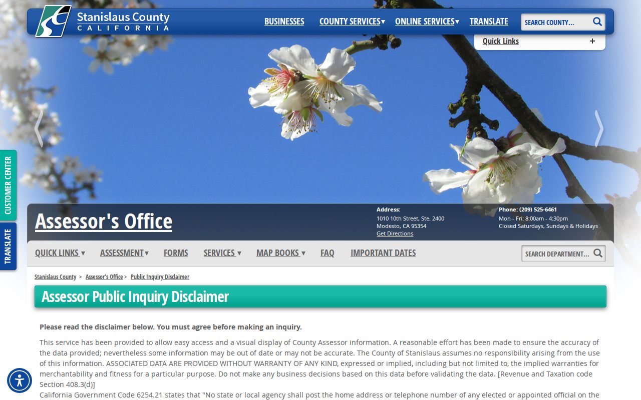
The image makes the key address caution visible: an address must first be converted into the parcel key that the free web inquiry accepts.
Stanislaus County Accela Street Lookup
The exact STANCO Accela address search is useful when a street needs to be reviewed segment by segment. Its Address mode shows a street-number range and a street-name field, with Look Up and Clear controls. The same selector also offers Parcel Information, Owner, Record Information, and Licensed Professional. That makes Accela a lead finder for permits, planning records, or address-linked activity, not a substitute for the assessor roll or deed index.
Search a short number range first. Compare each returned address with the GIS parcel pattern and record the APN when one is shown. The research capture could not verify every conditional field or result layout in the other modes, so the safest description is the visible search surface. Incorporated cities may keep their own permit systems, while county Accela coverage is most relevant to county records and unincorporated locations.
Note: An Accela result dates a public record or permit activity at an address; it does not identify every household member or prove that a named professional lived there.
GIS Makes a Stanislaus County Street Legible
Stanislaus County GIS Central supplies the geographic frame that a name index cannot. Parcel outlines, address points, map layers, city limits, annexations, county islands, supervisorial districts, Municipal Advisory Council areas, transportation features, rivers, fire districts, projects, and permits can place an address in the right jurisdiction. Current civic rosters and council areas can be checked through the County Boards and Commissions inventory, but those rosters are civic contacts, not household lists. Downloadable parcel shapes are geometry. The County’s assessment data must be acquired separately, so a visible shape is not itself an owner record.
For an address-record pass, locate the address, zoom until parcel boundaries make sense, and note the APN or parcel pattern. Follow the frontage rather than treating the postal city as a boundary. Then compare the shape with the Assessor record and the legal description in RecorderWorks. Across a long road, GIS is especially helpful for spotting parcel splits, large tracts, gaps, and county islands before an address list is assembled.
The current viewer’s exact identify, measure, or buffer controls were not confirmed in the accessible official interface. Treat the map as jurisdiction and geometry context, then verify title or assessment facts with the named custodian.
Stanislaus County Address to Deed Records
RecorderWorks is not keyed to a street name in the same way Accela is. The cleaner route is to get an APN or a current owner clue, then search the Stanislaus County RecorderWorks index by name, APN, legal description, date, book and page, map, or instrument number. In the newest deed, distinguish the grantor, the person or entity conveying an interest, from the grantee, the person or entity receiving it. Select the prior grantee as the next name to search when walking backward.
Keep the legal description beside the street address. Street numbers and postal labels can change, while a lot, tract, or metes-and-bounds description identifies the land in the instrument. A deed of trust is a security record rather than an ownership transfer. Reconveyances and substitutions generally concern that security interest. Before 1980, book and page references may matter; from 1980, annual continual instrument numbers are part of the index trail.
The research notes RecorderWorks copy charges of $6.75 for the first page, $3 for each additional page, and $2 for a seal. Confirm the current quote before ordering. The free index proves that a named party appeared in an indexed instrument; the image, legal description, and later conveyances are needed to test the chain.
Stanislaus County RecorderWorks Record Trail
RecorderWorks states that its name and document indexes run from January 1, 1850 to the present partial recording date. Name searches use a last name, with a partial first name recommended to reduce timeouts. Partial matching, date pairs, document type, document number, and map or book-page clues can narrow a common name. A document number opens detail, and selecting a person can pivot to that indexed name’s other documents sorted by type and recording date.
That 1850 label deserves a jurisdiction check. Stanislaus County was organized in 1854, and its county seat moved through Adamsville, Empire City, La Grange, Knights Ferry, and finally Modesto in 1871. An early result may therefore belong to a different administrative setting or reflect the index’s stated boundary rather than a modern county office. Read the date, place, document, and parties before attaching it to a present-day street.
RecorderWorks is a powerful chain tool, but it is still an index. Variant spellings, old maps, unreadable images, and legal descriptions can require counter, archive, or library research.
Postal Cities in Stanislaus County Street Records
Stanislaus County contains Modesto, Ceres, Turlock, Riverbank, Oakdale, Patterson, Newman, Hughson, and Waterford, along with many unincorporated communities. A USPS city label is a mail-routing choice, not proof of city limits. Modesto-labeled addresses can sit in South Modesto or another county island, and a parcel’s taxing jurisdiction remains tied to the land rather than to the preferred postal name.
For unincorporated road and land-development questions, Stanislaus County Public Works lists 1716 Morgan Road in Modesto, 209-525-4130, with weekday service from 8 to 5. Incorporated-city planning or engineering offices handle their own address and permit matters. Use GIS layers to select the likely custodian before requesting a record. Do not infer a city permit from a postal city.
No authoritative current source in the research establishes one universal county grid or a complete set of street-renumbering years. When an older address seems absent, compare its spelling and number with an old map, parcel geometry, APN, and legal description. The county-seat sequence is a stronger historical clue than a modern ZIP label.
Note: A postal city can guide delivery while the parcel’s legal description, assessment roll, and permit jurisdiction point to a different records office.
Stanislaus County Street Business Clues
Some street records describe activity at a place rather than a household. Stanislaus County Environmental Health’s facility inspection service can search by facility name, street name, or city. Food facilities, mobile food facilities, cottage-food operations, pools, small public water systems, wells, septic systems, and body-art facilities create address-linked dates and names. These entries can show that a public-facing activity was inspected at a location, but the facility name is not automatically the owner of the parcel or the person who lives there.
Pair a facility hit with a county fictitious business name filing or a state entity filing. An entity record can lead to status, principal or mailing addresses, agents, and a dated filing trail. The local FBN index and counter search add a registrant clue, though similar or duplicate trade names can be filed. Search the registrant, filing date, and address together rather than treating a name match as conclusive.
These business and inspection clues are most useful for dating use of a street segment, locating an operator, or separating two similar names. They are supporting evidence, not a current resident directory.
Stanislaus County Street Directory’s Historical Shelf
The modern street directory becomes thinner as it moves backward, but the Modesto Library’s Stanislaus Room and local-history services provide an important fallback. Library material described in the research includes county-town genealogy resources, newsletters, government documents, and city directories that can be retrieved from storage for in-library use. The directory holdings date to 1914, while the exact reverse-directory run and gaps remain a research question.
A criss-cross or reverse volume changes the search direction: start with a street and number, then read the listed occupant or business for that printed year. Record the volume year, street spelling, number, abbreviation key, and any owner or household mark. Compare that entry with the APN, deed, census schedule, newspaper notice, or map for the same period. The California State Archives county-and-city records inventory is another fallback for older deed and local-government series. A missing name can mean a gap in publication, a changed number, a spelling difference, or a person who was not listed.
When the task shifts from a current address chain to the volumes, publishers, holdings, and reading conventions, use the Stanislaus County city directory collection reference. The street directory should borrow the historical address clue without turning the modern record trail into a second historical catalog.
Stanislaus County Voter Records, Not a List
The California Secretary of State’s voter self-status tool asks for a first name, last name, date of birth, and either a California driver license or ID number or the last four numbers of a Social Security number. The authenticated result can show registration status, party and language preference, vote-by-mail or provisional-ballot status, polling place, election information, and county contact details for that voter. It is designed for self-verification, not a Stanislaus County street directory or neighbor search.
A voter file is a separate application channel. Elections Code §2194 limits release and use to approved purposes. Authorized requests can serve election, scholarly, journalistic, political, or qualifying governmental purposes, and the request identifies the geography, file type, intended use, and whether inactive records or participation history are needed. The released data excludes driver-license or ID numbers, the last four Social Security numbers, unique identifiers, and signatures. Confidential registrations are suppressed, including participants using protected address programs.
For personal confirmation, use the authenticated tool. For a permitted historical or civic project, contact Stanislaus County Elections at 209-525-5200 or use the formal file process. Neither route creates a casual list of everyone registered on a street.
Stanislaus County Street Directory Limits
A street directory can assemble public clues, but it cannot turn land records into a complete account of a household. An assessor entry describes a parcel and its assessment fields. A deed proves that a named party appeared in a recorded instrument. A mailing address tells the tax office where correspondence was directed. None of those facts, alone or together, proves who occupies the property today. A permit may name an applicant or licensed professional, while an inspection may name a facility.
Unlisted household members, temporary occupants, private contact details, utility customers, delivery records, and protected voters are outside the ordinary public address trail. Residential information held by the Department of Motor Vehicles is protected by the federal Driver’s Privacy Protection Act. Trusts, entities, and different mailing addresses also make a named owner an imperfect stand-in for a person at the door.
Lawful use. Stanislaus County address records are suitable for personal, lawful research such as family history, property curiosity, and civic inquiry. Using an address trail to stalk, harass, intimidate, or harm any person is prohibited.
When the question changes from “what records attach to this street?” to “which records can help distinguish one named person?”, use the Stanislaus County resident lookup workflow and keep the custodian’s limits attached to every result.